Areal Depletion Tab
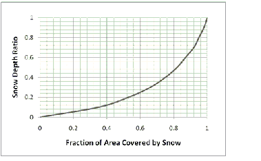
Areal depletion refers to the tendency of accumulated snow to melt non-uniformly over the surface of a subcatchment. As the melting process proceeds, the area covered by snow gets reduced. This behavior is described by an Areal Depletion Curve that plots the fraction of total area that remains snow covered against the ratio of the actual snow depth to the depth at which there is 100% cover. A typical ADC for a natural area is shown below.
The Areal Depletion page of the Climatology Editor dialog is used to specify points on the Areal Depletion Curves for both impervious and pervious surfaces within a project's study area. These curves define the relation between the area that remains snow covered and snow pack depth. Each curve is defined by 10 equal increments of relative depth ratio between 0 and 0.9. (Relative depth ratio is the ratio of an area's current snow depth to the depth at which there is 100% areal coverage).
Enter values in the data grid provided for the fraction of each area that remains snow covered at each specified relative depth ratio. Valid numbers must be between 0 and 1 (0% and 100%), and be increasing with increasing depth ratio.
Values can be initialized for impervious or pervious area by click on the Initialize Impervious or Initialize Impervious buttons. Clicking the Natural Area item fills the grid with values that are typical of natural areas. Clicking the No Depletion item will fill the grid with all 1's (100%), indicating that no areal depletion occurs. This is the default for new models.